

A dedicated research team, led by experts from the University of Tasmania, recently returned from a 54-day journey aboard CSIRO’s research vessel, the RV Investigator. Their mission? To delve into the impacts of the intense 2022 eruption of Tonga’s underwater Hunga Volcano.
The crew, comprising 40 researchers from various nations, wrapped up their intense study of the submarine volcano that erupted back in January 2022. This explosion produced an awe-inspiring ash plume reaching 58 kilometers into the sky, triggered widespread tsunamis across the Pacific, and covered an extensive area of the ocean floor with volcanic ash.
This monumental eruption also severed Tonga’s undersea telecommunications cables, leaving the island nation isolated and complicating everyday life for many residents for several weeks.
Over three years later, this research team, which included a specialist from Tonga Geological Services, collected vital information crucial for understanding the fierce dynamics that can lead to such powerful eruptions. They also investigated how the volcano and its surrounding marine ecosystems have altered in the aftershock of the eruption.
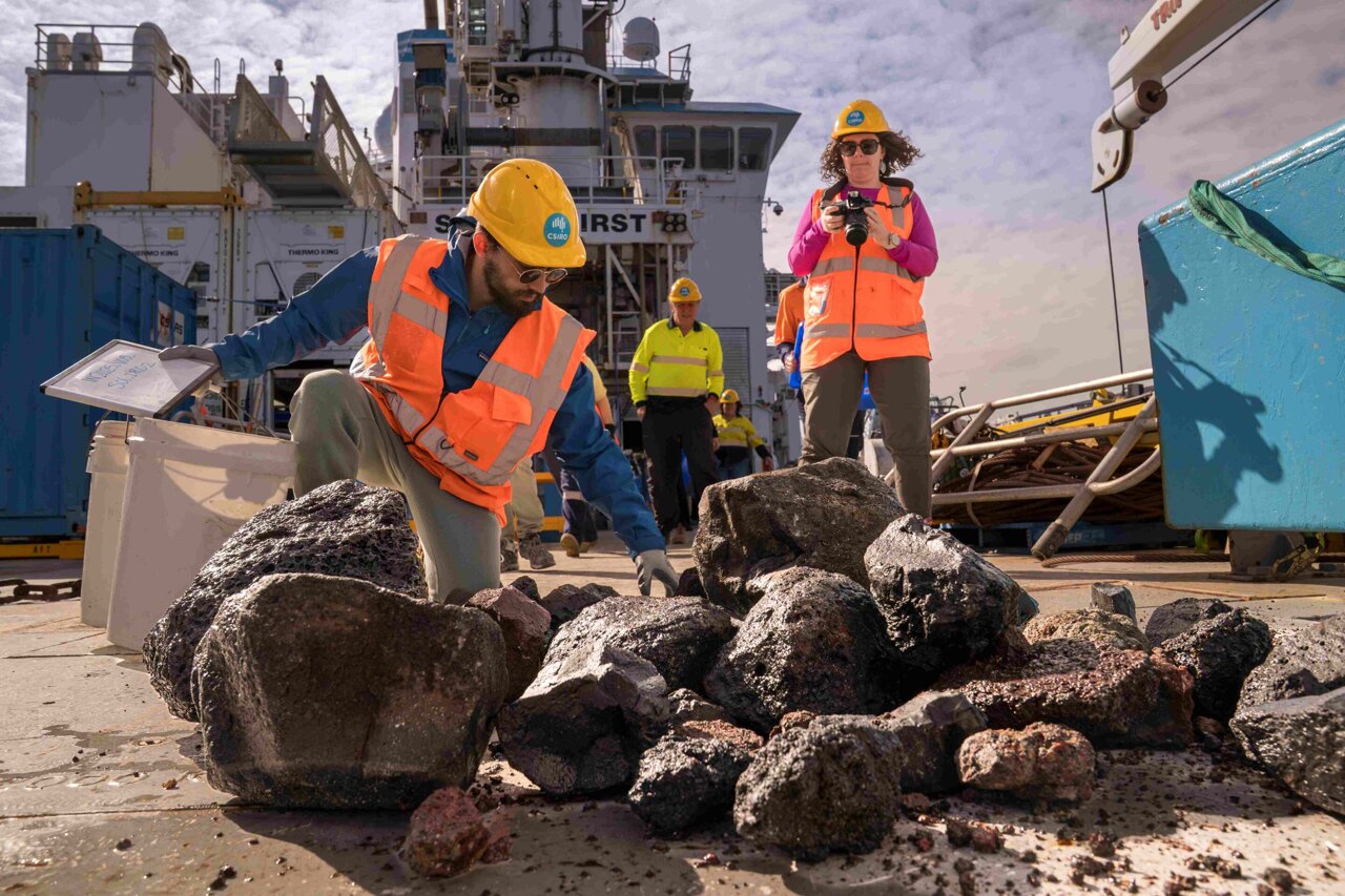
“Our operations included thorough mapping of the sea floor, collecting both seawater and rock samples, as well as extracting sediment cores and gathering biological evidence. This will really help us decode the volcanic processes and the marine life impacted by them,” explained Associate Professor Rebecca Carey, the Chief Scientist on the voyage from the University of Tasmania’s Center for Ore Deposit and Earth Sciences.
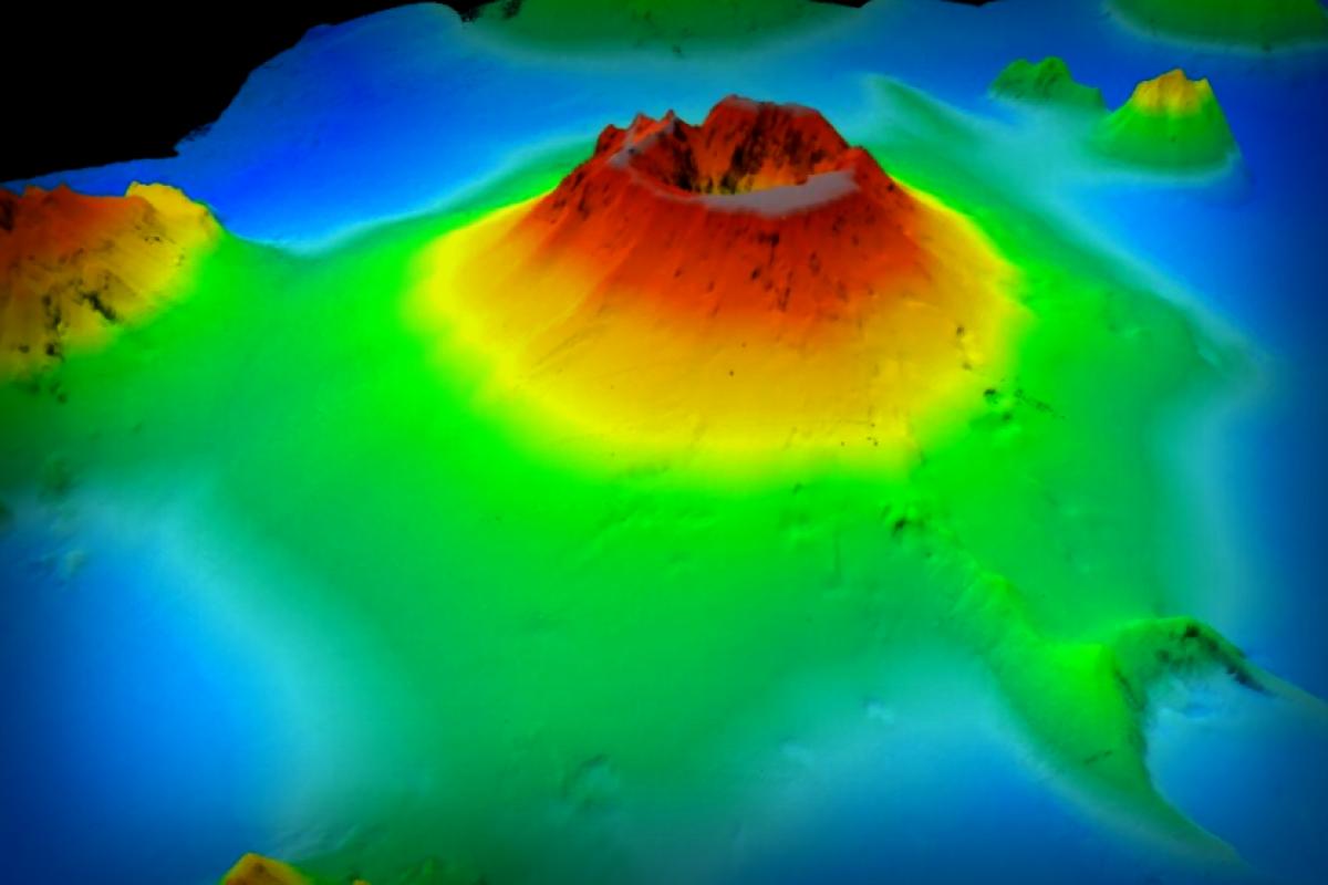
She further noted, “The mapping was particularly comprehensive. Our CSIRO mapping specialists onboard even generated a breathtaking view from the volcano’s caldera, making it feel like you were right there at ground level!”
The researchers utilized a variety of cutting-edge scientific instruments on the RV Investigator, which included a mammoth 24-meter piston corer and an underwater camera system, enabling them to execute over 160 scientific operations centered around the submarine volcano.
Among their findings, the team discovered that volcanic deposits from the eruption spread more than 80 kilometers in every direction from the site, with materials even affecting nearby volcanoes. They noted thick “mud soup” deposits that created unstable, shifting sections of the seabed – a complication for marine tenants attempting to thrive.
The eruption’s impact didn’t stop there; it compromised the volcanic structure itself, with debris accumulated atop the summit leading to the volcano’s steep slopes remaining unstable and prone to continued erosion.
Associate Professor Carey remarked on the grave implications of this ongoing instability – it could potentially lead to slope failures and local tsunami events, which underscores the pressing need for thorough monitoring and hazard response planning.
“We’ve amassed a wealth of data that will aid in peril assessments, shape risk models, and assist in planning for recovery efforts,” she stated. “Our research aims to foster better resilience and preparation for future volcanic events in the region. We’re eager to share our discoveries and the data gathered with both Tongan agencies and our partners in the Australian government and beyond.”
This international voyage united scientists from Australia, Tonga, Fiji, New Zealand, the U.K., and the U.S.
Mele Manu, the Chief Geologist at Tonga Geological Services (TGS), shared his thoughts on the essential nature of this mission. “Besides the volcanic threats, our new seabed maps show that Tonga faces risks from underwater landslides, mostly because of steep underwater hills and frequent quakes in the area, which could also lead to local tsunamis and very real danger to critical underwater infrastructure like communication cables. Enhancing our monitoring and early warning systems is crucial for protecting not just communities near the coast but also important national infrastructure.”
According to Toni Moate, Director of the CSIRO Marine National Facility, the knowledge gained from this voyage is instrumental in tackling major challenges in the Pacific region, especially concerning food security and bolstering resilience against natural disasters for Tongan citizens.
“The RV Investigator is a priceless asset in Australia’s research roster, and the incredible science we conduct significantly contributes to improving life not just for Australians but also for our neighbors across the Pacific,” Moate added.
Moving forward, the research team will spend months poring over the seabed mapping data along with the sediment and rock samples, and biological specimens collected during this critical expedition. The insights gleaned from their work are set to aid in Pacific disaster preparedness for years to come.
Provided by CSIRO
Originally published on Phys.org.