
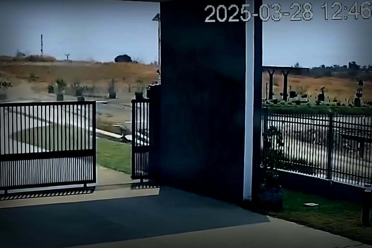
March 28 brought a real shaking experience to Myanmar, with a 7.7 magnitude earthquake hitting hard. Surprisingly, a camera streaming the event caught a remarkable video that laid bare the moment the ground ruptured and began to twist apart.
This CCTV footage chronicles the activity along Myanmar’s Sagaing Fault, located about 74.5 miles from where the earthquake originated. Remarkably, this is the first visual evidence scientists have of a fault line in action.
Geophysicist Jesse Kearse from Kyoto University in Japan found himself revisiting the YouTube upload multiple times. After a few views, he detected a curvature in the fault slip. In a statement released by the Seismological Society of America, he expressed his astonishment: “The curve, rather than a straight line across the screen, immediately triggered my curiosity.”
Kearse had studied curved slickenlines before—those scratches on fault surfaces which provide clues about past quakes. His research previously indicated that such curvatures could reveal the direction of fault movement. Yet witnessing the phenomenon occur in real-time had remained elusive until now. As he remarked, “I had never seen it happen live before.”
With his research partner, fellow geophysicist Yoshihiro Kaneko, Kearse delved into video analysis using a technique called pixel cross-correlation, breaking down the visuals frame by frame. They found that the fault shifted roughly 8.2 feet sideways over an approximate duration of 1.3 seconds, achieving a peak speed of about 10.5 feet per second.
This movement indicated that the earthquake had a pulse-like nature, “characterized by a sharp burst of slip traveling along the fault. It’s much like flicking a rug and watching ripples race along it,” Kearse elaborated in a different statement from Kyoto University. The findings were reported in the journal The Seismic Record on July 18.
Following the peak slip, the movement decelerated and straightened. The observations suggested that curvature, rather than just linear paths, might be quite common in slip behavior.
One potential reason for this curvature could be the relatively lower stress at the fault’s surface compared to deeper ground layers. Kearse explained, “The temporary stresses guide the fault off its expected path momentarily, before allowing it to realign as it should.”
This groundbreaking study points out that videos like the one shot during the Myanmar quake can be vital resources for researchers, potentially opening new avenues for understanding earthquake mechanics. Kearse notes in an article for The Conversation that research outcomes from such footage might well overhaul how we analyze seismic forces.
Analyzing the round slickenlines does suggest a link to the earthquake’s directional movement. The Myanmar quake clearly traveled from north to south, and the video-based models correlate with this directional truth, as he noted in The Conversation.
“Honestly, we hadn’t expected this video record would yield such a rich slew of detailed findings,” added Kearse. Ambitiously, this research could empower seismologists to forecast future shifts and assist in planning resilient urban structures, ultimately aiming to safeguard lives.
Next up, Kearse and his team aim to apply physics models for a deeper investigation into what shapes fault behavior.